
Landscape of Morocco: Morocco’s photogenic and impressive scenic beauty is unique and will amaze you when you see it for the first time. Many artists and fortune seekers have been inspired by the landscapes of this country. Below we take a closer look at which landscapes and panoramas you should definitely not miss.
Morocco is a very beautiful country, with many different landscapes and environments, which makes it such an interesting tourist destination. The pleasant climate, the omnipresent sun, the beautiful coastline, the High Plateau and Atlas Mountains, the Sahara Desert and the Rif Mountains – all these make a visit to the country more than worth it.
Four types of landscapes
Morocco can be divided into four types of natural landscapes: the Rif Mountains, the Atlas Mountains, the High Plateau of Eastern Morocco and the Northwestern Atlas. These landscapes are all equally attractive. In what other country can you find such overwhelming and unspoiled nature?
The Atlas Mountains
The Atlas Mountains do constitute the most impressive Moroccan landscape. The mountain range is divided into the Middle Atlas, High Atlas and Anti Atlas.
The High Atlas
The High Atlas Mountains has vast valleys with magnificent rivers and waterfalls. It is truly a beautiful landscape, attractive to many kinds of visitors. There are hiking trails, there are mountain bike trails, and you can go on donkey and horseback rides. Those tours are organized in the surrounding villages.
It is a very suitable landscape for photographers. In the High Atlas live the Berbers, a friendly and hospitable people. There are very nice picturesque villages, for example Oukaimeden (the most famous ski resort in Morocco), Tinerhir and Immouzer. Each village has its own unique peculiarities.
The Northwest Atlas
The Northwest Atlas is also worth a visit. Here you will find a combination of fertile plains along the coast, dry steppe, less fertile plateaus and a very fertile strip at the feet of the mountains, with many orchards.
Even more mountain ranges
There are other mountain ranges that are of particular interest to lovers of nature and adventure. The variety of flora here is unparalleled, and you will see landscapes that are unique and impressive, including the Amtoudi Peak (known for its best-preserved agadirs (xxx) in North Africa), the Chefchaouen Mountains (steep slopes offering maximum challenges) the Setti Gatma (fantastic trails and amazing waterfalls), the Trafraoute Mountains (dazzling, pink rock formations), the Oregano Mountains (covered with oregano plants), the Tan Tan Mountains (the only mountains with flattened peaks) and the Sarhro Mountains.
The Rif Mountains
The magnificent Rif Mountains is a mountain range stretching from Tangier in the West to the Moulouya River in the East and from the Mediterranean Sea in the North to the Ouargha River in the South. The mountain range takes its name from the Berber word “arif. It is part of the Alborian Sea region, but is not part of the Atlas Mountains.
The Rif region is known for its geographical diversity: you will find mountains, the sea, rivers and hills. The capital cities of the Rif region are: Nador, Al Hoceima, Ajdir, Taza and others. The original inhabitants of the Rif Mountains were the Berbers.
In the third century B.C. there was an invasion by the Phoenicians, followed in later centuries by the Romans and Byzantines.
The High Plateau of Eastern Morocco
In the rain shadow of the Atlas Mountains lies the broad Moulouya Valley. This valley stretches 530 km in length, directly from the Middle Atlas Mountains to the Mediterranean Sea. The High Plateau is located southeast of the Atlas Mountains and lies at an altitude of 1300 m.
It extends eastward as far as the Moroccan-Algerian border. It then suddenly bends to the southwest to slowly descend to the coast. There are several small towns, for example Asni and Tin Mal, which are worth visiting. The artificial lake Lalla Takerkoust, created after the construction of the hydroelectric dam, provides a good source of water for the surrounding villages.
The Sahara Desert
The part of the Sahara Desert that lies on Moroccan territory is known as the Moroccan Sahara or Southern Province. It is largely governed by Morocco, but has been disputed territory for some time.
You will find small villages around oases, from where you can take a camel ride into the desert. Popular activities include camel rides during sunrise or sunset through the sand dunes, ATV and 4×4 tours through the desert and duneboarding. The Berber villages have beautifully preserved their traditions and are interesting to visit.
The beaches
After visiting the sands of the Sahara Desert, you can walk on the sands of the Mediterranean beaches to take a dip in the Mediterranean or Atlantic Ocean and cool off. It is great to swim in the sea here, including in resorts like Agadir.
The beaches are long, white and clean, with many beach activities. There are many hotels and bars with lounger terraces, where you can tan and lounge. You can go fishing and windsurfing. The water there is clearacid and you won’t soon forget a stay at Moroccan beaches.
Landscape of Morocco are so varied that they can hardly be described in a few words, and the best thing to do is to take a trip to Morocco to see for yourself.
M’hamid the wild desert:
a small village also in the southeast of Morocco, M’hamid el Ghizlane is the center of the nomadic culture and was once a major stop for caravans traveling the Silk Road. Located about 60 kilometers from Erg Chigaga, the village is still wild and close to the largest desert area. Because it is less crowded than Merzouga, it is a good choice if you want to take in a more tranquil landscape. The sand dunes are more red and turn pink
Rocks painted in Tafraout
In 1984, Belgian artist Jean Verame created this breathtaking art piece. He painted certain large stone formations in shades of blue, pink, and green to create a striking contrast with the surrounding red granite environment. The distance from Tafraout the Village to the location is less than 4 km, and it may be reached by vehicle, bicycle, or foot. You may also go to Ait Mansour Valley, a sizable canyon that is home to some of the tallest palm palms in the nation.
Valley of Amtoudi
The berber village of Amtoudi is a small community with fewer than 300 families and a focus on traditional farming. The village is famous for an old granary that was built on the highest summit overlooking the entire valley and served as a grain storage facility for the entire community in the past. It is one of Morocco’s best-preserved granaries. The Amtoudi Valley is extremely vast, and you can go on a stroll across the river to see gorgeous naturally created pools and a Jacuzzi where you may swim while completely nude since nobody is usually present.
Beach at Legzira
You’ve certainly seen the stunning photos of the reddish archways that fall into the water at Legzira Beach. These arches were naturally created by erosion over many years, and you may visit them at low tide. This beach had four arches, but the thinnest one fell in August 2016. This beach is known as “a Jewel of Northwest Africa” and was listed as the 29th finest beach in the world out of the top 40. Apart from its unique sea-worm rock arches, Legzira is renowned for being a wonderful getaway spot. Still not very popular with visitors, there are just a few hotels and restaurants right next to the beach that provide a warm and welcome atmosphere. Legzira is a lovely little village renowned to surfers, intrepid travelers, and fish lovers that is situated just between Mirleft and Sidi Ifni.
Toubkal the highest Mountain
The Atlas Mountains’ highest peak, which is located in both Morocco and North Africa and is around 4167 meters above sea level, is a non-technical ascent that just demands a passable level of fitness, willpower, and drive. Toubkal is conveniently accessible from Marrakech through the Berber settlement of Imlil, where you may hire knowledgeable Morocco tour guides and porters to help with equipment, food supplies, and additional weight. But for seasoned mountaineers, it’s a manageable walk, and getting about is very simple. You will need two days to complete the summit; it takes an average of 4 hours to walk from Imlil Village to the stone traditionally built refuges, which serve as a base camp and are located at a height of 3207 meters. You can stay there and purchase food, or you can pitch your tent nearby for a small fee. The second day is the summit day, and it is strongly advised to be there two to three hours before dawn to take in the breathtaking views of the sun rising over the far Sahara desert. I’m hoping it will be a clear day for you!
Naturally, throughout the summer (from may), it’s a simple stroll; all you need are a jacket and some comfortable mountain shoes, but during the spring or if you’re a serious mountaineer during the winter, you must have ice-breakers, crampons, and your whole kit of snow equipment.
Ifni lake
Ifni Lake, also known as Lake d’Ifni, is a 6-hour hike that takes you from the refuge at 3,207 meters to Tizinanems at 3664 meters, where you can take in views of the Ifni Dome and the Toubkal massif, before going down to the lake at 2,312 meters. This lake’s azure water and lack of any surrounding trees or vegetation—just enormous mountains—create a stunning scene where you may go swimming and take a relaxing break. The true draw of this location is venturing far from the tourists and into the untamed Atlas Mountains.
waterfalls in Akchour
The lower waterfall, a much taller waterfall, cascades that share the same water stream as the main water falls, and the God’s Bridge are the main attractions of this hidden paradise in the Rif Mountains chain. To visit all of these natural spots in one day, it is advised to start very early in the morning and take the semi-triangular trail from the village of Akchour to the bridge before continuing on the main waterfall trail. It’s important to note that this trek is intended for mid-intermediate to advanced level hikers since completing the circle in one day requires lengthy river walking, a few challenging steep scrambles, and traversing slick wooden bridges. However, what you will see is worth working up a sweat for!
Paradise valley
Paradise Valley is a deep palm-lined gorge with a river crossing along the base, forming deep fresh natural blue water pools, a breathtaking landscape perfect for relaxing sunbathing and also if you dare camping, should be your favorite spot if you like cliff jumping combined with an average hike through a refreshing river. It is around 20 kilometers north of Agadir.
Ait bouguemez Valley
One of our favorite destinations in the whole nation is the Happy Valley, which is also known globally. The panorama of the farmer’s fields there is like something out of a storybook. The main village in the valley is Tabant, which is literally in the middle of the valley. From Tabant, you can walk to many small villages, and the locals are friendly and welcoming. If you can time your trip to arrive on a Sunday, you can also visit the weekly market, where you can buy very fresh produce and other items for your trek. You may trek to M’goun, the second-highest mountain in the nation at 4071 meters, from Mount Azourki’s top and take in the breathtaking views of the whole valley. The valley, which is located in the Atlas Mountains and is widely renowned for its hiking trips to amazing hidden local experiences, has a variety of wonderful guesthouse alternatives, tiny hostels, and things to do.
The Cathedral Rock Imsfran
The name is derived from its shape, and this 1872 m tall rock is one of the most stunning sights you will see on your journey to the Atlas Mountains. You can stroll around and take in the forest’s shades and greenery, or if you’re feeling particularly brave, you can hike up to the top and take in the view. This location is also well-liked for whitewater kayaking and rafting. Additionally, there is a tiny hostel (traditional berber guest house) nearby where you may stay the night and have a fantastic berber supper in a very unique and peaceful setting.
Zaouiet Ahansal to Taghia the berber pathway
Sidi Said Ahansan, an Islamic scholar and traveler, founded this small village in the high Atlas Mountains in the 13th century. He established an Islamic school there and attracted many followers. According to legend, he built his religious institutions wherever his cat jumped off his mule. Of course, the cat saw that lovely river crossing the mountains and creating green life wherever it passed by. Due to this, and since several strong nomad tribes visited that little settlement, the area developed both physically and intellectually. Libraries, schools, and communal granaries were some of the first examples of banking institutions because they were used for both storing and trade.
You can walk for about two hours from Zaouiat Ahansal to the lovely Berber village of Taghia. This route is famous for its narrow, high-altitude pathways, so it is not advised if you are afraid of heights. However, if you enjoy climbing, there are more than a hundred different routes to choose from, all of which are well-known to the local guides. Book 3 days tour from Marrakech to Fes with a local travel agency.
The Dades Gorges
The region eventually rose above the sea due to the movement of the earth’s crust, creating breathtaking reddish colored rock formations that are contrasted with fig trees and farmer fields all throughout the valley. Here, you can find many old, rusted buildings called Kasbah, such as “The Kasbah of Ait Arbi,” each of which has a unique tale to tell. You may go all the way to Amsemrir by driving along the famed route (seen in the picture below), where many automobile advertisements, including those for Land Rover, Chevrolet, and Volvo, were shot. and this route is used to shoot a lot of movies.
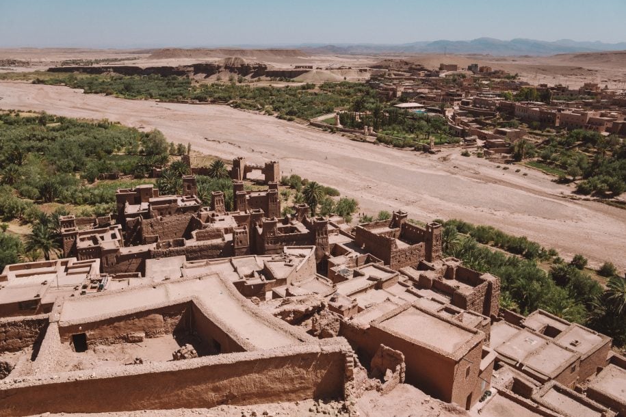
Ait benhaddou
This walled settlement, known as Ksar in Arabic, was constructed with the intention of serving as a major stopping point for caravans traveling between the Sahara desert and Marrakech. It has been conserved since the 16th century and is now a Unesco World Heritage Site. Ait Benhaddou is close to Ouarzazate, the Moroccan equivalent of Hollywood, where several films including The Message, Gladiator, Kingdom of Heaven, and Prince of Persia were produced. You’ll notice that it seems pretty similar.
Imi-n-Ifri the natural bridge
While hiking beneath the magnificent bridge, you’ll notice that the microclimate makes it a home for traveling birds, rare species of birds take some time to rest here before continuing their journey, and if you look west to shape of the the the bridge, you’ll notice that it’s a stone structure created by the water that flows underneath. Its slow but persistent nature forced conditions formed this fully functional limestone bridge, which pretty high about 60m from the river to the edge of the arch. There is no need for a guide since the staircase is pretty clear and should just take an hour to go down and return. When you get to the “Africa side” of the west opening river, you may have a super-cold, all-natural rejuvenating bath there.
Ouzoud waterfalls
The water is flowing via three drops at a height of 110 meters, and at the bottom are a number of fantastic traditional restaurants and cafés, where all the furnishings are exquisitely created and organically designed. The bottom is reached by a route that is covered by olive trees. It is best to avoid visiting during the summer or spring break since the location is not widely known to visitors but is well known to residents. To go to the caverns where water mills are used to grind wheat into flour, one must cross the river and travel for some 700 meters on a tight, challenging path.
Imsouane
One of the three main surf spots in the village, the Bay, has a very long right wave that lasts more than 1 km during low tide and leads you to the edge of the mountain where you can simply grab your board and hike back to the peak. This small surf and fishing village is situated between Essaouira and Agadir. It has wonderful beaches and surf spots. The owners of the surf stores, where you can purchase boards and bikinis in every size, are quite welcoming. The cuisine is just amazing. In the fishing port, boats with the fresh catch of the day arrive every day. You may purchase it straight from them and take it to your favorite nearby restaurant, where the meal will be prepared to your specifications (e.g., grilled, fried, or in a tagine). Leaving your own bag there will allow you to enjoy your surfing session and return when the dinner is ready. Additionally, there are several guest homes, rental flats, and villas available for accommodation.
Bin elouidane
This enormous lake, which is one of the largest in the entire kingdom of Morocco, is literally translated as “between the rivers” in the local Arabic. It is a dam that supplies the majority of the region’s power, but more importantly, it is the site of popular water sports like kayaking, rafting, fishing, wakeboarding, and paddle-boarding.
Leave a Reply